


A quick stroll into Pasig River’s future
Not too long ago, a typical walking route from the Manila Central Post Office to the inner sanctum of Fort Santiago would look something like this: Starting on Riverside Avenue, behind the razed post office building, you head straight toward Jones Bridge, and maybe tiptoe your way through the often wet, at times flooded, tunnel underneath. Upon reaching Plaza Mexico, you turn left into Soriano Avenue before, finally, making a right at General Luna Street, which leads to the fortress’ main gate.
By the time you arrive at your destination, you would have covered a distance of roughly 1.25 kilometers in 17 minutes—doable, if a bit unpleasant on a sweltering day, and a wee sketchy in spots by nightfall (especially back when street lighting on Riverside Avenue was scant).
But with the recent expansion of the Pasig River Esplanade—a key feature of the ongoing Pasig River rehabilitation project that aims to revitalize the 25-km stretch of the storied waterway—you can now do that very same trip in one scenic and leisurely stroll.
The new route, which makes use of the newly built pedestrian pathways stretching from the post office building all the way to Fort Santiago, is shorter by some 200 meters. Not a lot. But on paper, that should still shave off at least three minutes from your travel time—that is if you don’t end up sightseeing or going on a food trip like I did the last time I visited.
TikTok spots
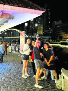
It was a Sunday. Anticipating thick crowds, I dropped by the esplanade, by bicycle, at past 9 p.m. But much to my surprise—and what a nice surprise it was—the place still brimmed with energy and bustled with activity.
At the easternmost edge, where you could watch cars cross the MacArthur Bridge and LRT-1 trains trudge along the tracks, flocks of teenagers roamed around, looking for “aesthetic” spots to shoot their TikTok videos.
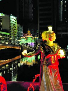
A man with a fishing pole cast a line into the river and restlessly waited by the balustrades for a fish to take a bait. On the planter benches, where gumamela and kalachuchi grew, parents sat and rested, as their toddlers tried their mightiest to reach for the water gushing from the fountains. And in the basin, among the lighted waterworks, stood sculptures of “Pandanggo sa Ilaw” dancers, the glass atop their heads cleverly doubling as light fixtures.
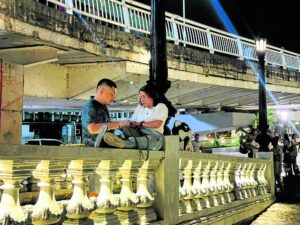
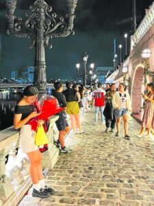
This segment of the esplanade, the first to open, in January 2024, was done in neoclassical fashion—with ornate angel reliefs and Victorian-style street lamps—to match the designs of the neighboring post office and Jones Bridge. As such, the sort of European vibe it evoked quickly became popular among couples looking for a romantic spot for dates, or even wedding proposals.
Nine phases
True enough, it felt like the Valentine season had been extended in this part of the city, with numerous couples walking hand in hand, being bugged by enterprising kids selling bouquets of knitted flowers and balloons with twinkling lights.
Dubbed as “Pasig Bigyang Buhay Muli,” the Pasig River initiative is a project by the Inter-Agency Council for the Pasig River Urban Development, a body chaired by Department of Human Settlements and Urban Development (DHSUD) Secretary Jerry Acuzar, and formed by virtue of Executive Order No. 35 issued by President Ferdinand Marcos Jr.
This P18-billion project—divided into nine phases across Manila, Mandaluyong, Makati, Pasig, Taguig, and Taytay, Rizal—has a mission that’s as difficult as it is simple, Marcos said in a recent speech: “to bring back the river to its pristine state, [and] make it a vibrant waterway once again for life, for culture, and for mobility.”
While the President had vowed to “relentlessly pursue” this ambitious undertaking, it remains to be seen whether or not its completion target of 2028 would be met, especially with the Pasig River Expressway—a proposed elevated expressway that will traverse the river—reportedly still “technically on the table.”
But at the very least, from what we have seen so far, the first three phases of the project had more or less touched on some of the key points mentioned by the President, giving us a limited, but nonetheless promising glimpse of the project’s broader vision.
A case for community-building
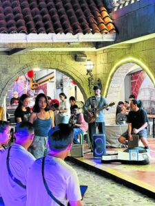
While beautification is an integral part of the rehabilitation process, there’s also a concerted push to develop the esplanade into a hub where local businesses can flourish. Phase 2, which opened five months after the first, showed just that.
The centerpiece of this cobblestoned section—which starts from Jones Bridge and ends at Plaza Mexico—is an arcade from which smells of grilled meats, takoyaki, and sweet corn wafted. But aside from food stalls, the one-story building also houses a photo studio, and various stalls selling local arts, crafts, and beauty products.
On any given day, people are free to ride bikes in this area. But in times of heavy foot traffic, like weekend nights, it’s best to simply dismount and push your bike. The walkway here is just 3 meters wide, so you would have to do a lot of squeezing through—not only against fellow visitors, but also past buskers, dogs in strollers, and mascots emoting to a “meme-ified” version of a Billie Eilish hit.
If the first two phases flirted with Pasig River’s potential for tourism and commerce, the third one—which was inaugurated just last month—made a case for community-building, active mobility, and preservation of cultural heritage.

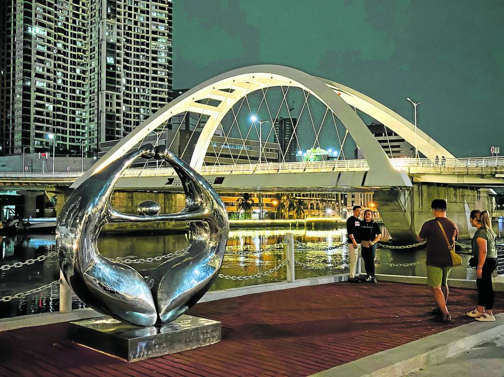
Once you reach Plaza Mexico, the esplanade opens up significantly, thanks to the construction of a 2,000-sqm activity area. Also in the vicinity is the China-Philippines Friendship Park, where you could get a close and unobstructed view of the Binondo-Intramuros Bridge, whose eye-catching arch has, in recent years, become an imposing presence in the old Manila downtown’s riverfront vista.
For outdoor recreation
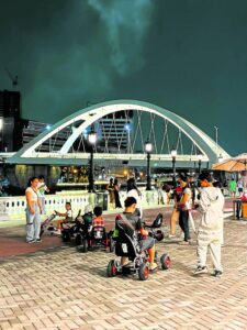
It was around this spot that the pathways previously terminated. But with the opening of Phase 3, people can now continue walking toward The Maestranza Wall, the unkempt parcel of land in front of which used to be parking a lot. Now, it’s a 240-meter, 16-meter-wide boardwalk, perfect for pedestrians, joggers, cyclists, and others seeking safe spaces for outdoor recreational activities.
And with the Plaza Mexico ferry station nearby, one could only imagine the kind of public transportation network we can potentially have, if authorities can devise an efficient system that would maximize and synergize these otherwise underutilized modalities.
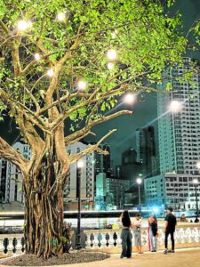
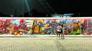
The Maestranza boardwalk also serves as a “heritage corridor” of sorts, with tarpaulin murals of the National Artist Carlos “Botong” Francisco’s iconic works like “Tinikling” and “First Mass at Limasawa.” There was a row of food kiosks with benches and tables, and pedal-powered go-karts for kids to enjoy. But in the future, we were told, this space could also hold various art installations and events, giving artists a picturesque venue to showcase their wares.
Walk further and you would notice that the esplanade was now manned not by regular security personnel, but by the Intramuros guards, or as the kids called them, “guardia civil.” A sign that we were nearing Fort Santiago.
The path, sprawling, spotless, and beautifully lit, eventually led to the Soledad Promenade, an existing riverwalk that used to be accessible only through Fort Santiago’s main entrance. Now, visitors can enter the historical landmark via the Postigo Nuestra Señora de Soledad river gate, where a ticket booth had been put up.
Not too far away, just by the closed off metal fence, stood a mango tree—illuminated by spherical lanterns—signaling the end of the esplanade. Just for now, I hope. On my way back, I saw a project poster saying that, once the project is completed, one can cycle 25 kilometers from one end of the Pasig River to the other in 75 minutes.
Well, now for the remaining 24 kilometers.