


Maguindanao Sur floods bring misery to 38,000 residents
COTABATO CITY—At least 35 barangays in four towns of Maguindanao del Sur continued to be submerged in floods, aggravated by the rains spawned by the intertropical convergence zone in the area early this week.
Joel Mamon, director of the Office of Civil Defense in the Bangsamoro Autonomous Region in Muslim Mindanao, said the latest flooding affected 7,664 households or 38,329 individuals in the towns of Buluan, Pandag, Paglat and General Salipada K. Pendatun.
The four towns were covered by the first aerial survey conducted by provincial officials on Thursday to see the extent of the damage wrought by floods in the province.
Maguindanao del Sur has been placed under a state of calamity since September, following heavy flooding that in Buluan town alone, forced hundreds of patients to be moved out of the Buluan District Hospital (BDH) when water entered its premises at the height of the Sept. 19 floods.
The worst
Dr. Ariff Baguindali, chief of the Integrated Provincial Health Office, who oversees the BDH, said it was the first time in 50 years that floodwaters reached the hospital located at the town center.
The patients were transferred to a women and training center building in a higher part of Buluan, and stayed there for about a month before they were moved back to the hospital.
Local authorities have yet to figure out the extent of the damage wrought by the floods all over the province.
Six more towns would soon be covered by the next aerial survey—Sultan sa Barongis, Rajah Buayan, Shariff Saydona Mustapha, Datu Salibo and Datu Piang and Talitay towns, according to Col. Edwin Parcia, commander of the Tactical Operations Group 12 (TOG-12) of the Philippine Air Force that provided the aircraft for the survey.
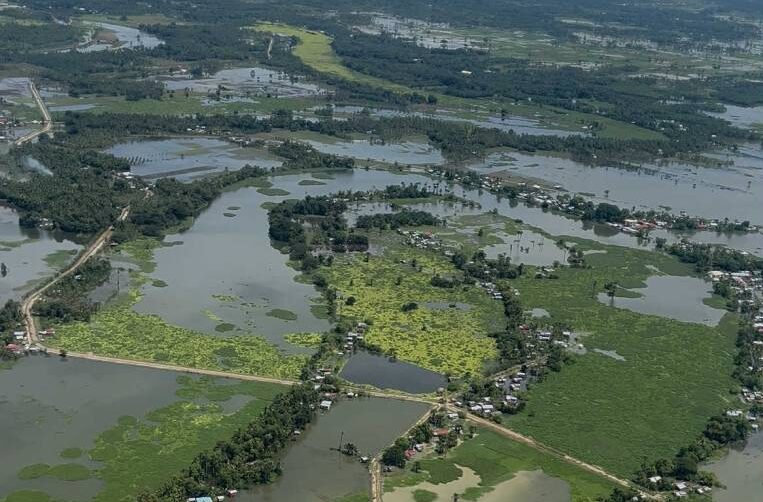
The initial survey, carried out by TOG-12 using a Bell 412 helicopter and with support from the 6th Infantry Division, showed many parts of the province remained submerged due to the lack of a proper drainage system capable of channeling water from neighboring provinces, such as South Cotabato and Sultan Kudarat.
Catch basin
Since Maguindanao del Sur’s topography serves as nature’s catch basin for floodwaters coming from surrounding provinces, floodwaters tend to stay in low-lying areas in the province, causing extensive damage to communities.

Among the long-term solutions being considered by provincial officials are the creation of large water banks or reservoirs on vacant lands to help lower flood levels that reach roads and residential areas at their peak. These reservoirs will also serve as water sources for farmers during the dry season brought by El Niño.
The aerial survey also showed officials how the main channel of the Buluan River had been blocked by siltation and the buildup of water hyacinths, causing overflow and flooding in nearby areas.
To address this, Mamon said they agreed to implement several measures, including a boat-based ocular inspection to locate the river’s original course and the formulation of a dredging plan for the Buluan River.
He said they would present the findings during the Maguindanao del Sur Provincial Disaster Risk Reduction and Management Council meeting on Tuesday.
The survey team plans to explore small water impounding systems for affected farmlands and conduct follow-up aerial assessments in other flood-hit municipalities, including Sultan sa Barongis, Rajah Buayan, Shariff Saydona Mustapha, Datu Salibo, Datu Piang and Talitay.