

40 most scenic roads for day tripping

It has been said time and again that the journey is as important as the destination. For road warriors and family road trippers, the journey on wheels fuels the excitement for a consummate motoring experience.
Below is a list of 40 roads which I have graded as my personal best based on road quality, safety, touristic value, Instagram-worthiness, and the X-factor that will make you come back again and again.
Batanes. If you want to have a road unto yourself where you can lie on the pavement and gaze at the sky, this is the place to be. You can drive around the main island of Batan or Sabtang just across the channel and be mesmerized by the picturesque wind-swept coastal villages.
Patapat Viaduct. This bridge in Pagudpud snakes through the cliffs of Luzon’s northernmost road system with the panorama of the vast open sea. It connects Ilocos Norte to Cagayan and the rest of the Valley region.
Bessang Pass. A vast natural park in the mountain towns of Ilocos Sur, which was the site of the decisive battle between Filipino and American guerillas versus Japanese troops during the Second World War in 1945. A roadside memorial monument in Cervantes is a must-stop for a snapshot and get a feel of the hell called war above the clouds.
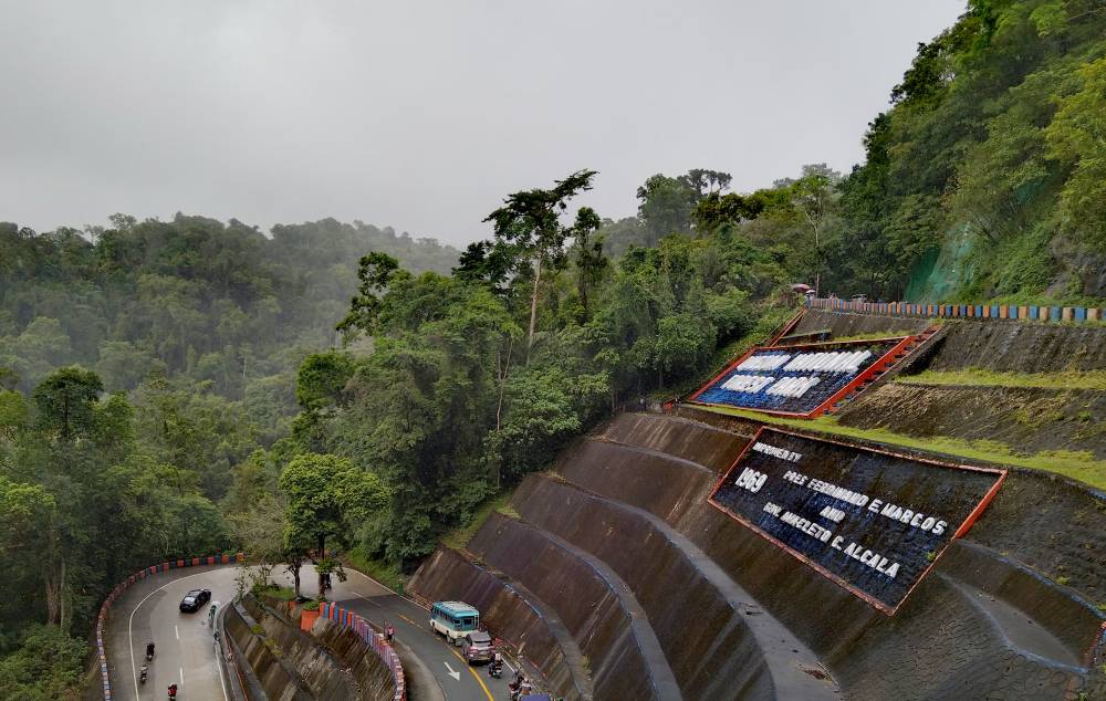
Kennon Road. Despite frequent landslides, this remains the favorite road enroute to Baguio City for light vehicles because of the shorter distance. Despite the familiarity, there is no “umay” factor and I often look forward to the Lion’s Head and the strawberry taho vendors nearby
Halsema Highway. Named after an American civil engineer, this is the main mountain thoroughfare in the Cordillera ranges. What seemed like a one-way ticket to paradise in the 1990s is now among the best paved roads, on top having the most breathtaking sights.
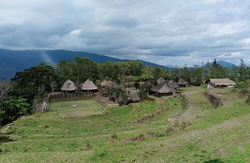
Mt. Polis Road. Connecting Mountain Province and Banaue, this is a corridor of indigenous culture where Igorot way of life is very much alive in the tribal houses, rice terraces and local folks in traditional garb.
Tinoc. Declared the highest point in the Philippine highway system, this is like the Mt Apo of every true-blue motorist. It can be reached from the Ifugao provincial road and Kiangan town.
Hungduan. An hour’s drive away from Banaue, Ifugao, it is home to one of the most picturesque assemblage of rice terraces untouched by modernization.
Ambuklao Road. A dizzying zigzag which serves as the shortcut from Baguio to the Cagayan Valleya region, and cuts through Ambuklao Dam in Bokod, Benguet. Its challenging twists and turns make Kennon feel like child’s play.
Lubuagan. A remote town in Kalinga, which is about an hour away from the provincial capital city of Tabuk. In 1900, Gen. Emilio Aguinaldo and his soldiers stayed here for more than 2 months as they eluded the pursuing US troops during the Philippine- American War.
Nagtipunan. The backdoor and shortcut of Quirino Province which connects to Aurora via a winding highway along the Cagayan River and onto the sleepy shores of the Pacific Ocean.
Aurora National Park. Named after former First Lady Aurora Aragon-Quezon who was killed by Huk rebels in the 1950s in the Bongabon side of mountain pass. It is the main access to Aurora province and its famed beaches and surfing sites.
Pantabangan. Located upper Nueva Ecija, it overlooks the hydroelectric dam which submerged the old town, and has since become a spot for water-related recreation and a preferred location of resort hotels.
Mt Pinatubo Lahar Trail. There are no roads to speak of here, but if you want to test the mettle of SUVs and pickup trucks, you have come to the right place. It’s a surreal rockscape akin to a Mad Max Thunderdome scene, but the experience of driving through sand, water and rocks is simply unparalleled.
Balete Pass. Once called Dalton Pass in honor of US general John Dalton who got killed by a Japanese sniper during the liberation of the area, it is a winding zigzag which is part of the Pan-Philippine Highway. A beautiful World War 2 shrine and memorial park serves as the provincial boundary between Nueva Ecija and Nueva Vizcaya.

Malico. An upland village claimed by Nueva Vizcaya and Pangasinan, this is a faster access to the Cagayan Valley via TPLEX in Urdaneta City. It is dotted with pine trees, view deck cafes and the The Mangili Tindaan Historical Nature Park which boasts of a US 2 M4 Sherman battle tank war relic.
Marilaque. A 117.5-km highway which cuts through Marikina, Rizal, Laguna, and Quezon, and a top-of-mind for bikers and motorcycle riders. Once known for reckless rider stunts particularly in the Devil’s Corner in Antipolo, sanity has been restored with the strict enforcement of driving laws and the presence of mobile police.
Laguna Lake. A long-time favorite for long before loop rides became a fad, it embraces several lakeshore towns in Laguna and Rizal which are dotted with lots of IG-worthy spots and an infinity of interesting stuff in between.
Quezon National Park. Situated in Atimonan, this mountain zigzag serves like a “diversion road” as it bypasses portions of the Manila South Road. Called “eme” (letter “M”) by old drivers, it has a weighbridge and rest area for pitsops, snack or a snapshot.
Bondoc Peninsula. Literally the “road less travelled” in Quezon province, it takes pride in some of the best-kept secret powdery beaches and heritage structures hiding from plain sight.
Marinduque. A heart-shaped island south of Quezon, this has already established a reputation for being a motorcycling haven with the Puso Moto tourism program. The most exciting part of its network is the Luzon Datum of 1911 park in Mogpog town which is regarded as the geodetic center of the archipelago.
Tablas. If you want to roam in Romblon, start with this island which is home to most of the municipalities, a seaport, and an airport. With very few vehicles around, swinging around is simply bliss.
Camarines Norte. This 66-km zigzag in Sta. Elena is the longest in the country, and was the major artery to the south until the late 1990s. On its boundary with Camarines Sur is “Bitukang Manok”, another 28-km zigzag which is teeming with hardwood trees.
Mayon Circumferential. If there’s something more amazing than ogling at the perfect-coned volcano, it is driving, or for marathoners running, around the municipalities on its base. On top of the visual treat, you can also stop in every town to sample the local delicacies and stash native crafts.
Cagraray. This once hard-to-reach island in Bacacay, Albay has been the envy of many mayors because of its four-lane, high-grade roads which will put to shame the national highway in the Bicol region. Interestingly, it is the posh Misibis Bay Resort which made this world-class highway possible, courtesy of a controversial fugitive party-list congressman.
Partido. Not too long ago, this district in eastern Camarines Sur has been notorious for unpleasant driving experiences. The concreting of dirt roads in recent years has unlocked tourism potentials in some obscure destinations such as Siruma, Presentacion, Lagonoy and Garchitorena.

Catanduanes. Don’t let its old moniker of being the “Land of Howling Wind” and the recent typhoon scare you. This island province in the Bicol Region has rebranded a decade ago into being “The Happy Island” to ensure that the mobility and overall experience always have a happy ending.
Biliran. Connected by a short bridge to its former mother province of Leyte, this idyllic island province boasts of splendid and panoramic roads, and countless beaches and waterfalls.
Sogod. An urban hub in Southern Leyte where the rich Sogod Bay dive site is named after, it is host a meandering mountain pass which includes the 110-m Agas-Agas Bridge, the tallest in the country.
Cebu Transcentral Highway (TCH). Located at the central peaks of Cebu, it is the main artery which connects the eastern and western coasts of the island province. Because of its elevation, cool climate, and scenery, the upland villages around it have become like a small version of Tagaytay ridge.
Bohol Central Highway. Stretching from Loon to Talibon town, this is a proof that not all roads are created equal. It has the highest concentration of tourist attractions every 10 minutes of driving or so, which includes Loboc River, Bilar Man-Made Forest, and the Chocolate Hills, and scores of intriguing pitstops along the way.
Siquijor. With only about a 70-km circumferential road, this is paradise in a nutshell which you can easily navigate on a motorcycle … or a broomstick (just kidding). A must-try is “Fairy Walk” at the Cambugahay Falls in Lazi where Anne Curtis set the internet ablaze.
Negros Oriental. The province bagged the hosting of the recently-concluded Tour De Cebu which saw over a hundred vintage cars navigating its vast road network. Its most scenic portions are in Valencia, Mabinay, Canlaon, and the iconic Balinsasayaw Twin Lakes in Sibulan.
Guimaras. Dubbed as the country’s “mango capital”, it wants to capitalize on its wide roads and bike-related activities to be the “biking capital”
Camiguin. A charming island province off northern Mindanao which is touted as the country’s “lanzones capital”. It’s circumferential road is just about 66 kms, which pilgrims walk during the Holy Week for the penitential Panaad ritual. The best spot is Tongatok Cliff where you can witness the kaleidoscopic sunset.
Claveria. The site of a fatal mid-1990s plane crash, this upland town in Misamis Oriental has grown into a mountain resort and food trip destination. Just an hour away from Cagayan de Oro City, it is a fave getaway for food and drink with a view.
Buda. In Mindanao, the shortest distance between two points is not a straight line, but a spiral one. This road is the fastest and most scenic connection between Davao City and the southern part of Bukidnon which is awash in tropical fruits, agricultural produce, and settlements of native lumad tribes.
Siargao. Apart from surfing, this island is riddled with roadside wonders such as the Human Drone in Pilar, and the Cloud 9 boardwalk and Catangnan (aka AFAM) bridge in Gen. Luna, which are best explored on rented motorcycles.
Dinagat. An archipelagic province off northern Mindanao, it has freshly-paved roads which are perhaps just over a decade old, not to mention the unspoilt seas which are almost within arm’s reach from the driver’s seat.

Davao Occidental. Carved out of Davao Del Sur a decade ago, this new province has some of Mindanao’s coziest roads, owing to its topography and scenery. Among the prettiest spots are the Sta. Cruz viewpoint and the provincial capitol site in Malita, which both overlook the Davao Gulf.