


Averting another Pinatubo disaster
CITY OF SAN FERNANDO—One day in June 2001, my Nokia phone rang several times. When I finally took the call, it was Gen. Reynaldo Berroya, then chief of the Central Luzon police.
“Tonette, we’re about to fly to Mt. Pinatubo. I’m checking the water in the crater. Oxfam (the UK aid agency) and Dr. [Kelvin] Rodolfo are asking for assistance. I’ll take you along on the next flight,” he said in Filipino.
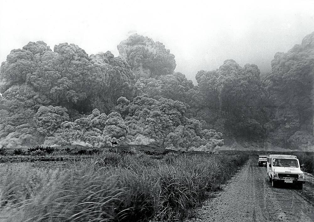
The following month, I got a ride on a Huey because Berroya asked one passenger to get off. As the helicopter hovered over the crater, the green-blue water in what had become a wide, bean-shaped lake filled me with awe. This was the volcano that terrified us Kapampangans and Central Luzon residents during its June 15, 1991, eruption.
Easing the pressure
But there was little time to enjoy the scene because the blades were fighting strong winds on the Zambales side of the 1,400-meter-high volcano.
The Huey ascended over the ranges, then descended until we reached the nearly flooded helipad of Camp Olivas in Pampanga.
It took me a few days to reach Dr. Kelvin Rodolfo, a native of San Antonio, Zambales. He confirmed Oxfam’s proposal to breach the lowest point of the crater on the Maraunot side.
That, he said, was necessary to ease the pressure of a crater collapse or, at the very least, prevent water from breaking out and driving lahar toward the town of Botolan. I broke the story on the trenching of the crater.
In mid-August, my bureau chief Rolly Fernandez sent me to Botolan. Scrimping on my coverage budget because I didn’t know how many days the assignment would last, I slept in the convent of Iba Bishop Deogracias Yñiguez.
Radio room
Then Zambales Gov. Vicente Magsaysay called to ask if I was interested in joining an engineer named Ed, who was flying to Mt. Pinatubo using Magsaysay’s two-seat Cessna. The jester that he was, Magsaysay said the pilot had many healed wounds on his body—his way of saying the pilot had survived several crashes. It scared me, but Ed and I flew anyway.
On Berroya’s instruction, I stayed at the Botolan town hall, where I met Mayor Roger Yap. Berroya gave me access to a room with a two-way radio, so I heard the exchanges between engineers of the Department of Public Works and Highways (DPWH) and geologists from the Philippine Institute of Volcanology and Seismology (Phivolcs) who were at the crater doing preliminary work.
Yap confirmed that the local government had no funds to build the canal or even feed the workers. He eventually found the money—from his own pocket.
Dr. Raymundo Punongbayan, then Phivolcs director, arrived one morning, landing on a hill overlooking the Bucao River. Metro Manila-based reporters jostled for space, but he approached me and the Philippine Star’s Jen Velarmino first. Why? I think because we were “local,” and thus grounded.
When a police colonel denied me access to the radio room for the first time, I watched through a glass panel as Punongbayan and DPWH’s Florante “Dante” Soriquez spoke intensely.
When they stepped out, I asked what they had talked about. Punongbayan blurted, “Design.” Soriquez shied away, saying only, “Mamaya na (Later), Tonette.”
I called Rodolfo. He said he had no say in the canal’s design. He cited a study indicating that the area near the canal was not too hard.
By this time, Pampanga Gov. Lito Lapid had suggested siphoning off the water from the crater lake. Some nonscientists laughed at his idea, but an American geologist thought it was somehow feasible.
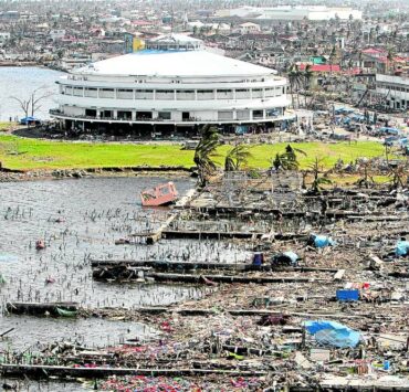
The plan to evacuate 40,000 residents was announced. My prayer was: Lord, please drive the lahar out at once to the South China Sea. Do not let it detour to communities.
‘Atang’
On the rainy morning of Aug. 20, I hopped onto an Army truck with more than 40 Aetas from Botolan, whom Yap had hired to carve a canal using only shovels and rock picks.

We traveled by land through Pampanga and then Tarlac, though we could have taken the more difficult ascent from Botolan or San Marcelino.
The Aetas preferred to approach Mt. Pinatubo via Sta. Juliana in Capas, Tarlac. Along the way, the small black pig they brought as “atang” (offering) to the mountain deity Apo Namalyari fell off the truck thrice. Was that an omen?
Assisted by my Aeta guide Gerry (tribal name: “Bituka”), we hiked to the crater past the community of Tarukan. There was a spot with a cellular phone signal, enough for me to file a story and send a photo.
Broadcast journalist Bernadette Sembrano joined the camp-out atop Mt. Pinatubo. We saw that the Aetas had only dried fish, canned goods, and rice. Led by an Aeta named Domulot, they were determined to finish the task to “save Botolan.” They said that was what Yap asked them to do.
Along with some DPWH workers, they began digging on Aug. 23.
Still in harm’s way
By Sept. 5, the mouth of the canal was the size of a 50-cavan sack of rice lying flat. They kept digging until the trench dipped just below the water level—about 2 meters deep.
“Parang umihi lang (It was like a mere trickle),” Punongbayan said, without admitting failure. No lahar avalanches occurred, but the danger of a massive outflow was not yet over.
Back in Sta. Juliana, a wire agency asked for photos “for Manila out,” meaning for international publication. I gave three exclusive photos, but nothing eased my worry that Botolan remained in harm’s way.
After the 2002 rainy season, the mouth of the Maraunot notch widened by more than 2 meters, according to Rodolfo. No massive lahar flows were monitored, thus sparing communities below the volcano.