


Pagasa expects wet weekend even as ‘Bising’ leaves PH
The low-pressure area off northern Luzon intensified into Tropical Depression “Bising” on Friday, but the state weather bureau expected the system to leave the Philippine area of responsibility within 12 hours.
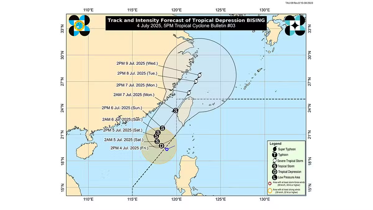
In its 5 p.m. bulletin on Friday, the Philippine Atmospheric, Geophysical and Astronomical Services Administration (Pagasa) located the center of Bising 345 kilometers west northwest of Calayan, Cagayan.
With maximum sustained winds of 55 km per hour and gustiness of up to 70 km/h, Bising was moving northwestward at 15 km/h.
But the weather bureau said Bising may bring strong to gale-force gusts over northern Luzon until Sunday and enhance the southwest monsoon, affecting most of Luzon, including Mindoro, Marinduque, Romblon, Palawan and Antique.
Expected to strengthen
Pagasa noted that the forecast track is highly uncertain, but Bising will likely intensify into a tropical storm as it moves northest of Taiwan.
There is still the possibility that Bising may shift southward toward the Philippines by early Monday morning, but that is “less likely,” Pagasa said.
Still, Pagasa noted that the southwest monsoon remains active and advised more caution to seafarers who may experience rough seas along the western seaboards of Babuyan Islands and Ilocos Norte.
Mariners of small seacrafts, including all types of motorbancas, are advised not to venture out to sea under these conditions, especially if inexperienced or operating ill-equipped vessels.
The bureau also expected up to moderate seas in the northwestern seaboard of Ilocos Sur and the seaboard of Batanes as well as the coastal areas of La Union and Pangasinan.
Mariners were advised to avoid navigation under these conditions and take added precautionary measures.
Bising developed three weeks after Tropical Depression “Auring,” the first weather system in the country this year, emerged on June 11.
Auring made landfall in Taiwan the following day, but soon weakened after landfall.