


Rains already topped July average; more as ‘Dante’ meets ‘Emong’
So intense was the rainfall brought by the enhanced southwest monsoon (“habagat”) in the past three days that it breached the average amount of rainfall for the entire July, causing flash floods in different parts of the country.
The Philippine Atmospheric, Geophysical and Astronomical Services Administration (Pagasa) gave the update as it also warned of more rainy days to come due to a rare “interaction” of two tropical storms, also called the Fujiwhara Effect.
“The rainfall brought by the enhanced southwest monsoon from July 19 to 21, exceeded the normal monthly rainfall for Science Garden in Quezon City in just a three-day period. That’s why we saw significant flooding not only in Metro Manila but also in neighboring provinces,” Pagasa weather forecasting section assistant chief Christopher Perez said at a Malacañang briefing on Wednesday.
Based on Pagasa data, from July 19 to July 21 alone, 558.8 millimeters of rain were recorded at the Science Garden station in Quezon City.
This was higher than the 493.3 mm average monthly rainfall for the entire July for the past 30 years.
The most intense volume was recorded on July 21 when 285.8 mm of rain fell within 24 hours.
More rains coming
While lower than the 24-hour volume recorded during the onslaught of Supertyphoon “Carina” (international name: Gaemi) and the southwest monsoon in 2024 (458 mm) and Tropical Storm “Ondoy” (Ketsana) in 2009 (455 mm), the recent habagat caused flash floods in several provinces in western Luzon, including Metro Manila.
Perez clarified that the rainfall volume was just one of many factors behind the latest flooding.
Heavy and torrential rains will persist in the western part of Luzon, several parts of Bicol region, Palawan area and Western Visayas “in the next two to three days,” or from Friday to Saturday, he said.
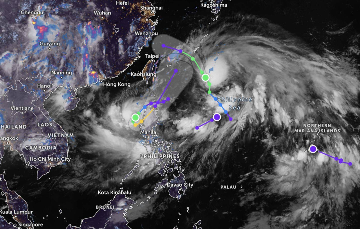
As of Pagasa’s 5 p.m. bulletin on Wednesday, there were two tropical cyclones already inside the Philippine area of responsibility (PAR), both having intensified into a tropical storm.
A third low pressure area, still outside the PAR, was also being monitored.
Tropical Storm “Dante” (Francisco) and Tropical Storm “Emong” are expected to enhance the southwest monsoon.
Dante’s center was monitored to be at 835 km northeast of extreme northern Luzon. It was moving north northwestward at 25 kilometers per hour (kph), with maximum sustained winds of 65 kph and gustiness of up to 80 kph.
Dante should be over the Philippine Sea on Thursday and leaving the PAR in the afternoon or evening, according to Pagasa’s tracking.
Emong path, ‘interaction’
Emong was plotted moving southwest of the West Philippine Sea, prompting Pagasa to raise Signal No. 1 over several northern Luzon areas on Wednesday afternoon.
Emong’s center was estimated to be 150 km west of Laoag City, Ilocos Norte. It packed maximum sustained winds of 65 kph near the center and gustiness of up to 80 kph.
A gale warning was raised over northern Luzon’s western seaboard.
Signal No. 1 was raised in Ilocos Norte, Ilocos Sur, La Union, the northern and western portions of Pangasinan, Apayao, Abra and Benguet.
Emong was expected to move southwestward on Wednesday night before looping over the West Philippine Sea by Thursday morning up to the afternoon due to its “interaction” with Dante.
‘’This means Emong will stay longer in the western part of Luzon and cause strong rains and winds,” said Pagasa weather specialist John Manalo, explaining how the Fujiwara Effect had affected the forecast.
The phenomenon may cause two cyclones to spin around each other or combine into one stronger system.
Emong is seen making landfall over Ilocos Sur, La Union, or Pangasinan on Thursday night or early Friday morning. Emong will then cross the mountainous terrain of northern Luzon, reducing its strength, before leaving the mainland through the Luzon Strait.
Ground saturated
“These heavy rains in the next days are caused by Emong which we expect to be slowly moving toward the sea at the western part of Ilocos region. Emong and Dante will also enhance the southwest monsoon, which will cause heavy rains and strong winds in places where there [are] no [TWCS, or tropical cyclone wind signals] raised,” Perez explained.
“Even if the rains in your areas are not that much, the ground there are already saturated with water due to the rains in the past days and can cause landslides,” he said.

“Floodwater levels will also subside slower because of the anticipated rains in the coming days,” Perez added.
Agriculture losses
The Department of Agriculture (DA) said severe weather had led to P323.15 million in losses, with some 14,772 farmers and fisherfolk affected in the Ilocos, Cagayan Valley, Central Luzon, Calabarzon, Mimaropa, Bicol, Western Visayas and Socckskargen.
The heavy rains damaged 10,595 metric tons of local produce covering 15,868 hectares of agricultural land.
Based on the DA tally, rice accounted for 65.79 percent of the overall damage, amounting to P212.60 million. High-value crops followed at P82.63 million, corn at P22.13 million, livestock and poultry at P5.33 million, and cassava at P353,080.
At a briefing on Wednesday, Agriculture Assistant Secretary Arnel de Mesa said the DA was not expecting any surge in the prices of food items, including vegetables.
Agriculture Secretary Francisco Tiu Laurel Jr. said the DA has essential resources ready for distribution, such as seeds and financial aid, for the speedy recovery of affected farmers.
About P545 million worth of agricultural inputs have been prepared, while the National Food Authority released 500 bags of rice to the local government of Palawan for distribution.
Some P268 million in indemnification will also be given to 45,980 insured affected farmers, through the Philippine Crop Insurance Corp.
Damage to infra
The Office of Civil Defense said the latest flooding caused at least P4 billion in infrastructure damage across the country.
The National Disaster Risk Reduction and Management Council reported a total of 508 flooded areas in the Ilocos region, Cagayan Valley, Central Luzon, Calabarzon, Mimaropa, Bicol region, Western Visayas, Central Visayas, Zamboanga Peninsula, Soccsksargen, Caraga, National Capital Region and Negros Island Region.
It also recorded 53 incidents of landslide, collapsed structure, tornado/destructive winds, maritime incidents and drowning. —With reports from Gabryelle Dumalag, Dianne Sampang and PNA.