Return of illegal quarry in Mt. Banahaw alarms green group

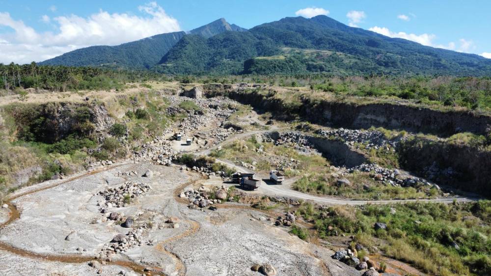
LUCENA CITY—Environmentalist group Tanggol Kalikasan (TK) on Tuesday revealed that illegal quarrying was back on the slopes of Mt. Banahaw in Sariaya town in Quezon province.
Jay Lim, project officer of TK, also a public interest law firm, said they received reports of destructive rock quarrying along Lagnas River in the villages of Concepcion Pinagbakuran and Concepcion Bugon.
“A villager told us that dynamite was being used in the quarrying operation. The blast often shook their house. They were afraid; that’s why they came to us for help,” Lim told the Inquirer in an interview Tuesday.
He said he went to the area on April 13 and personally saw the heavy equipment that was being used in the quarry operation. Lim said they heard an explosion when they were approaching the site.
Protected landscape
“What shocked us was when we found out that the quarry site is inside the MBSCPL (Mt. Banahaw-San Cristobal Protected Landscape) based on the map and GPS (global positioning system),” he said.
Lim said that the kilometer-long buffer zone before entering MBSCPL was the “first layer of defense” to protect Mt. Banahaw, which is classified as a “protected area.”
“Quarrying inside the buffer zone is strictly prohibited to protect Banahaw,” he said.In 2009, Congress passed Republic Act No. 9847, declaring Mt. Banahaw and the nearby Mt. San Cristobal a protected landscape in Quezon and Laguna provinces.
Under RA 9847, “buffer zones refer to identified areas outside the boundaries of and immediately adjacent to designated protected areas that need special development control to avoid or minimize harm to the protected area.
The law also emphasized that mineral exploration or extraction, quarrying of sand, gravel, guano, limestone, or any material within the buffer zone, especially if it is inside the protected area, is prohibited.
Quezon Provincial Mining and Regulatory Board (PMRB) chief Rommel Sarmiento said he ordered a team to validate the TK information.
“Once it is proven that there is quarrying inside the buffer zone or protected area, we will stop it and file criminal charges against the culprits,” Sarmiento said in a phone interview.
The quarry operation at the slope of Mt. Banahaw, like any mining activity in other parts of the province, is under the control and supervision of the PMRB, with the local government performing only ministerial functions as provided under the Local Government Code.
Nilo Tamoria, the Department of Environment and Natural Resources (DENR) director in Calabarzon (Cavite, Laguna, Batangas, Rizal and Quezon) said in a private message that he would order the local DENR office and the Mines and Geosciences Bureau to validate the reports and facilitate the filing of corresponding cases if they find that there is indeed quarrying there.
According to Randy Tronila, Sariaya municipal environment and natural resources officer, the explosions in the area were caused by detonations of confiscated explosives by the military.
“The Army asked permission from the local government to detonate the explosives in the area,” he said.
The municipal government has also posted on social media a copy of the request from the military’s Southern Luzon Command to allow them to detonate the confiscated explosives in parts of Barangays Sto. Cristo and Sampaloc 2 on April 11, not at the illegal quarry sites in the villages of Concepcion Pinagbakuran and Concepcion Bugon.
Flood control program
The Sariaya government has been limiting quarry operations to the riverbed as part of its flood control program. There is also quarrying in the villages of Sampaloc 2, Sto. Cristo, Tumbaga, Canda, Limbon and Castañas on the banks of the Janagdong and Lagnas rivers.
Illegal quarry operators, however, entice owners of low-yielding farms, particularly coconut plantations, to sell them their land, which they would turn into quarry sites.
In 2009, two persons drowned at a mining site in Sto. Cristo when they slid into a quarry hole at the onslaught of Typhoon “Santi” (international name: Mirinae).
Lagnas Bridge connecting Maharlika Highway collapsed at the height of Typhoon “Rosing” (Angela) in 1995 due to the strong river current and rolling boulders from the upper part of Banahaw.


