‘Romina’ to dump heavy rains over Quezon, Bicol provinces

Heavy to intense rainfall is expected over the provinces of Quezon, Camarines Norte, Camarines Sur and Catanduanes on Monday due to the combined effects of the shear line, the area where warm and cold winds meet, and a tropical depression which the weather bureau has named “Romina.”
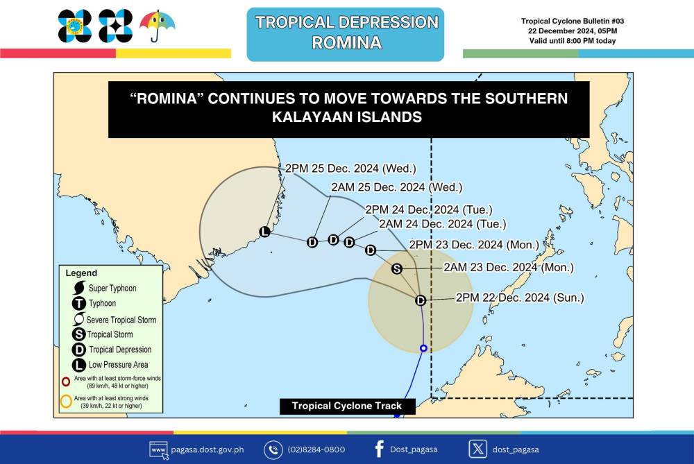
As of 5 p.m. Sunday, the weather disturbance was located over the coastal waters of Rurok Island in Kalayaan, Palawan, prompting the Philippine Atmospheric, Geophysical and Astronomical Services Administration (Pagasa) to raise Tropical Cyclone Wind Signal No. 1 over Balabac, Palawan, and Kalayaan Islands despite Romina still being outside the Philippine area of responsibility (PAR).
With maximum sustained winds of 55 kilometers per hour near the center and gustiness of up to 70 kph, Romina may briefly become a tropical storm within the next 12 hours before returning to tropical depression category for the rest of the forecast period.
Local name, bulletin
Pagasa said that as of Sunday afternoon, Romina was moving northward with a speed of 35 kph. It may pass near the southern portion of the Kalayaan Islands by Monday before continuing to move away from the Philippine landmass given its current track.
Although still outside PAR, the storm was already given the local name of Romina to allow the state weather bureau to issue a tropical cyclone bulletin and warn residents of current wind signals.
“Because we have a [tropical cyclone wind] signal at Kalayaan Islands, we need to show a bulletin. So far, we don’t issue a bulletin if a storm does not have a local name,” said Lorie de la Cruz of Pagasa’s weather division.
She added that this was the second time Pagasa named a weather disturbance while it was still outside PAR. The first time was in 2013 when Supertyphoon “Yolanda” (international name: Haiyan) was just about to hit the country.


