


‘West PH Sea’ prominence on Google Maps cheered
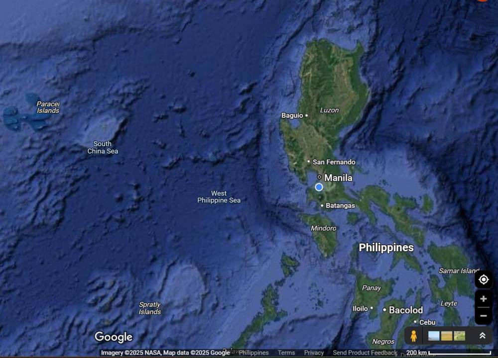
Social media had been abuzz since Monday as netizens noticed that “West Philippine Sea” (WPS) was appearing prominently on Google Maps to mark the stretch of water west of the Philippine archipelago.
Many saw it as an affirmation of the country’s sovereign rights over the 270-kilometer area in the face of China’s expansionist claim over much of the South China Sea, which Beijing cites as basis to justify its island building and its harassment of Philippine vessels and fisherfolk.
The Armed Forces of the Philippines and several lawmakers also took notice, with the former calling a “truthful representation.”
But in a statement sent to the Inquirer, a Google spokesperson clarified that the West Philippine Sea “has always been labeled on Google Maps.”
“We recently made this label easier to see at additional zoom levels,” said the spokesperson, who declined to respond to further questions.
Google Maps, the digital mapping service offered by Google, uses a combination of user contribution, satellite imagery, geospatial data sources and official government data to create and update its maps.
According to Google, the names people see on the Maps app “are based on your country’s location.” A VPN (virtual private network) test by the Inquirer showed that the WPS designation could be seen in other states or territories like the United States and Hong Kong.
The Philippine government, under the Aquino III administration, started calling the area West Philippine Sea in 2011 to distinguish parts of the South China Sea that are within the country’s exclusive economic zone (EEZ).
A year and five months after the fact, President Benigno Aquino III signed Administrative Order No. 29 to make the designation official. In a statement, Aquino then explained that the WPS covered “the Luzon Sea as well as the waters around, within and adjacent to the Kalayaan Island Group and Bajo de Masinloc, also known as Scarborough Shoal.”
The Aquino administration began making the distinction after Chinese patrol ships harassed a Philippine scientific vessel and fired across the bows of Philippine fishing boats in waters within the country’s claim in the Spratly chain of islands.
‘More than an update’
For Speaker Martin Romualdez, the Google Maps labeling of the WPS was a “strong affirmation of the Philippines’ sovereign rights and the increasing global support for its maritime claims.”
“The proper and consistent labeling of the West Philippine Sea on the widely used platform Google Maps is welcome news for every Filipino,” Romualdez said in a statement on Tuesday. “This simple yet powerful update reflects the growing global acknowledgment of the Philippines’ sovereign rights over the maritime areas within our [EEZ].”
He added that the decision to reflect the WPS label “is more than a map update. It’s a geopolitical affirmation. This platform shapes global consciousness, and this recognition adds significant weight to our cause.”
“We hope this move will encourage other mapping services, institutions and governments to follow suit and acknowledge what the law and justice clearly uphold,” he said.
Boosting public awareness
AFP spokesperson Col. Francel Margareth Padilla said the inclusion of the WPS in Google Maps also upheld the 2016 arbitral ruling that invalidated Beijing’s sweeping claims in the South China Sea.
“As defenders of national sovereignty, the AFP sees this as a valuable contribution to truthful representation and public awareness,” Padilla said at a press briefing at Camp Aguinaldo.

Senate Majority Leader Francis Tolentino said it also meant that the WPS was “slowly but surely gaining recognition” from the international community and reputable global institutions.
“It is also an affirmation of the correctness of the Philippines’ current policy to assert its sovereign rights in line with international law and multilateralism,” said Tolentino, principal author of the landmark Philippine Maritime Zones Act or Republic Act No. 12064.
According to Tolentino, equally significant are the statements of support that the Philippines has been receiving from several nations, including global leaders like the United States and the European Union.
“The world is taking notice because of our unity and collective efforts as a people. And this is despite the aggressive actions of China to drive away Philippine government ships and fishermen from our very own exclusive economic zone,” he said.
Power of labeling
“There is power in labeling,” added Sen. Joel Villanueva. “In this case, it clarifies ownership and establishes identity, serving as a global recognition of our rightful ownership of WPS.”
“The designation and identification by Google Maps of the West Philippine Sea is a huge victory of our country against the bullying tactics of China that has been trying to invade our territory,” he added.
Tolentino said he hoped that Google Maps would next integrate the “Talampas ng Pilipinas,’’ a resource-rich undersea rise located in Luzon’s eastern seaboard.
He noted that the map for the Talampas was officially received by the International Seabed Authority on March 27. —WITH REPORTS FROM NESTOR CORRALES AND TINA G. SANTOS