


Maps and WPS issues

Many years ago, I advised teachers in a seminar to add map reading in their Araling Panlipunan classes because many Gen Z cannot point out Cebu or Sulu on a map without consulting Google. Worse, some cannot even take or give simple directions. They may know right, left, straight, or turn, but they don’t know how to head north, east, west, and south (N-E-W-S) without a compass or Google. I always found it mercenary that my high school chemistry textbooks didn’t have the periodic table. You had to buy those separately from the bookstore. Maps are absent in Araling Panlipunan textbooks, because they have to be bought separately.
I remember my college history professors coming to class with large wall maps that are now obsolete and gathering dust in a corner of our office. I wonder how much geography students learn in K-12 because I do not use maps in class, presuming they have stock knowledge and know what I am talking about.
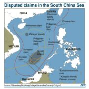
When I asked a school administrator why our disputed territory in the West Philippine Sea was not indicated in their learning materials, her answer shocked me. “We shouldn’t put the disputed territory in our learning materials because ‘China might get mad at us.‘” This is the type of teacher who schooled our “Tsinadors” in the Senate. I faced that teacher down and asked, ”How will the next generation appreciate the issue, or fight for our territorial rights if these are not in our learning materials?” The problem is deeper than I thought. I was informed by a member of the Philippine Map Collectors Society (Phimcos) that all the maps, atlases, and globes sold for reference or classroom use are made in China. No wonder our disputed territory is within their invented nine-dash line that encroaches on our exclusive economic zone in the West Philippine Sea.
A current exhibit at the National Museum branch in Cebu, organized by Phimcos, highlights “Classics of Philippine Cartography” from the earliest maps in the 16th century to our day that trace the evolution of the shape and form of the Philippines through the centuries. It is an exhibit that should be shared elsewhere in the country, if not with original maps, at least with good reproductions. Historical maps will help us appreciate the fine points that will be raised in the much-awaited debate between the filibustering Sen. Rodante Marcoleta and the erudite retired Supreme Court Senior Associate Justice Antonio Carpio, who has become an expert on Philippine cartography after his careful study of evidence in issues concerning the West Philippine Sea.
Carpio recently delivered an illustrated lecture on a little-known Spanish map of the Philippine archipelago published in 1875 by the Spanish Royal Hydrographic Office, which was the official map of the territory known at the time. It includes the disputed Spratlys as well as the Kalayaan Island Group that Marcoleta wants to serve China on a silver platter. Reissued in 1888, the map, according to Carpio, was the last official map of the Spanish Philippines. Since my area of interest and expertise is in maps of the Philippines from the 16th to 18th centuries, this 19th-century map by Claudio Montero y Gay, head of the Comisión Hidrográfica de Filipinas, is too late for me. While I have heard of Montero before, I didn’t know he was responsible for about 35 nautical charts of the Philippine archipelago. As maps mark developments in the drawing or writing of the Earth or “geo-graphia,” Montero cites earlier authorities like the Spanish Alejandro Malaspina, the English W. T. Bates, and Commander Reed. As I had just visited Basilan, I was intrigued by the French admiral Cecille, who put Basilan on his maps in 1845.
When the United States annexed the Philippines following its victory in the 1898 Spanish-American War, it adopted and reissued the 1875 Carta General del Archipielago Filipino, adding to it military telegraph and cable lines as well as military department boundaries. Since this 1875 map became the official Spanish and US map of Philippine territory at the time, it is an undisputed primary source that determines our territorial claims against China’s encroachment. We may not have the arms, the army, and the navy to match those of China, but we have the historical and legal materials to argue our case in the arena of law and international public opinion.
Carpio pointed out that the map of the Philippines that accompanied the Treaty of Paris had an incomplete rendering of the Spratly Islands. He said that: “The geographical coordinates dictated by US negotiators enclosed the islands to be ceded by Spain. However, the geographic coordinates did not match the map attached to the Treaty.” The geographical coordinates did not include Scarborough Shoal and much of the Spratlys, so the clarification required renegotiation in the 1900 Treaty of Washington and payment of a $100,000 “consideration.” By 1938, Scarborough Shoal was determined by the US as part of the Philippine territory.
There is so much on the transition between Spain and the Philippines that I didn’t learn in school. It is high time we look back to appreciate our territory.
—————-
Comments are welcome at ambeth.ocampo@inquirer.net

Wealth, power, and the Filipino future