Ysla de locos or ponientas?

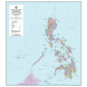
My students find me weird because in the age of Google and Waze, I continue to be intrigued by physical maps of the Philippines. I am often asked to explain my fascination with early maps—from the late 16th to the early 17th centuries—when the geographic information on them is dated, often very inaccurate. My first encounter with old maps was in a plastic display case at the Lopez Museum and Library, which had an assortment of old maps, views, prints, and pages of old periodicals. I leafed through these repeatedly, absorbed by the idea that I was literally looking at the past through primary source material.
In the mid-1980s, friends were bringing home for sale—maps bought cheaply from old bookstores and antique shops in Paris and Madrid. These were not exorbitantly priced at the time. I was a college student living on an allowance, but I was able to slowly build a collection of maps that could be used to show how the shape of the Philippines, as we know it today, came about over the centuries. In a 1540 map of Asia by Munster, the seas were infested with all sorts of sea monsters and mermaids. On the upper right side of the map was an archipelago of 7,448 islands. I thought to myself: Was this the Philippine archipelago? But there was one small island farther below the archipelago marked as “Puloan.” This was obviously Palawan. Where were Luzon, the Visayas, and Mindanao?
Surely, sailors and explorers who had been to our corner of the world knew of these islands, but in those days, when European countries were scouting for overseas territories, it did not make sense to list everything on a map and have rivals take uninhabited or “unknown” islands.
One of the earliest maps of Southeast Asia, printed in 1598, was made by Dutchman Jan Huygen van Linschoten, who used materials stolen from the Portuguese. Linschoten was secretary of the Portuguese archbishop of Goa. In the first separate map of the Philippines, published by Kaerius in 1598, the islands were known by two names. Translated from the original Latin or German, these were the “Archipelago of Saint Lazarus” imposed by Ferdinand Magellan when he “discovered” the Philippines, and the other was simply “Philippine Islands.”
In some maps, the Philippines is identified as the “Baruses.” When the survivors of the Magellan expedition returned to Spain and related the “discovery” of what we know today as Cebu, Leyte, Samar, and Panay, the 16th-century cartographer Gerard Mercator indicated these might be what the second-century cartographer Ptolemy called the “Barussae.” Ptolemy gave names to other lands in the Malay world: Maniolas, Barusas, Baroussai, Taprobana, etc. Based on this, some people identified the Visayas as Barusas and Manila as Maniolas.
In K-12, I learned that the Chinese arrived on our shores way ahead of the Spaniards, sometime between the ninth to the tenth centuries; they knew present-day Mindoro or Bai as Ma-yi or Ma-i. Some travelers thought Luzon was the entire archipelago, or used the name to refer to the archipelago. Luzon is supposed to have come from the word lu-sung or “luson,” which originally referred to the mortar used to pound rice. In early Japanese maps and references, the islands and their people were referred to as “Ruson” because they are linguistically challenged and pronounce “i” as “r.”
Did you know that the Pacific Ocean or the “maris pacifici,” got its name because Magellan thought its waters were calm or pacific? That is, compared with the rough waters of the Atlantic Ocean. The islanders Magellan first met in what was to become the Philippines were friendly and hospitable so the islands were sometimes referred to as the “Vall Seu Parigne” (Valley without Peril) in sharp contrast to the people of the Marianas, who were labeled as thieves and their land the Islas de las Ladrones or “Isle of Thieves,” a historical name that is politically incorrect today.
I wonder, because “y” and “i” are often interchangeable in Spanish, as in the hero of the “Noli me Tangere,” who we know as “Ibarra,” is spelled as “Ybarra” by Rizal. Well, there was a story that Ilocos up north, sometimes spelled as “Ylocos” was the short form of “Y/Isla de Locos” (Island of Crazy People) or even “Y Locos” (And Crazies). Worse, there is the province of Cagayan that makes Spaniards laugh because if the place name is actually rooted in the verb “cagar” (to defecate) then what does that make of Cagayan de Oro? How does that fit in the fake news that Elpidio Quirino slept on a P5,000-bed in Malacañang and used a gold orinola? I would think that in Quirino’s time, or even earlier, the Palace had modern plumbing and toilets, the President did not need an orinola.
In some old Spanish maps, the Philippines was known as the Islas del Poniente or the Isles of the West because Magellan traveled to the islands using the Western route from Spain. To the Portuguese who used the Eastern route, the Philippines was the Islas del Oriente (Isles of the East). Imagine if we changed from Filipinas to Islas del Poniente, we would not be Filipinos today; we would be “Ponientas”!
—————-
Comments are welcome at aocampo@ateneo.edu
Ambeth is a Public Historian whose research covers 19th century Philippines: its art, culture, and the people who figure in the birth of the nation. Professor and former Chair, Department of History, Ateneo de Manila University, he writes a widely-read editorial page column for the Philippine Daily Inquirer, and has published over 30 books—the most recent being: Martial Law: Looking Back 15 (Anvil, 2021) and Yaman: History and Heritage in Philippine Money (Bangko Sentral ng Pilipinas, 2021).













State and statelessness in South Asia