


‘Forgotten’ 1875 map backs PH vs China sea claim–Carpio
There is a “forgotten” map dating back to the Spanish colonial era and adopted during the American period that Filipinos need to rediscover.
For it shows that Panatag (Scarborough) Shoal and the entire Kalayaan Group of Islands (or the Spratlys)—two of the most contentious points in the country’s maritime dispute with China—have always been part of Philippine territory, according to former Supreme Court Senior Associate Justice Antonio Carpio.
The map, the “1875 Carta General del Archipielago Filipino,” is another “answer” that can disprove China’s claim that it has historical rights over these islands and maritime features, Carpio said.
Donation
It depicts all the islands within the Philippine archipelago that were ceded to the United States by Spain, including those omitted in the 1898 Treaty of Paris, he said.
Crucially, it shows “B. Masinloc,” which referred to Bajo de Masinloc, another local name for Scarborough, and even Pag-asa (Thitu) Island, as part of the Philippine territory.
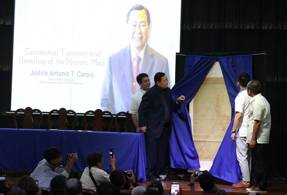
On Thursday, Carpio donated to the National Library of the Philippines (NLP) a copy of what he described as the “definitive” and “most complete” document drawing up the national territory predating the Treaty of Paris.
“This is an old map that we have to be reacquainted with again because we have forgotten this map,” Carpio said in a speech at the turnover ceremony at the NLP. He was able to procure the copy—likely the only one currently in existence in the country—from a map dealer.
Legal scholars and researchers, he said, had been “remiss” in highlighting in public discourse that the 1900 Treaty of Washington was intended to rectify details in the 1898 Treaty of Paris regarding the territory that was handed over to the United States.
The coordinates recognized in the Treaty of Paris were flawed, Carpio said, because they excluded islands, such as the Scarborough, the Spratlys and the Cagayan de Sulu (now Mapun Island in Tawi-Tawi province) and Sibutu.
These islands were left outside the “treaty lines.”
“The text of the treaty did not match with the map attached to the treaty, and that was the problem. Because after signing the Treaty of Paris of 1898, the Americans came here and the Spanish garrison in Cagayan de Sulu and Sibutu (two of the excluded areas) refused to vacate.’’
“And so there was a dispute,” he said, that forced the Americans to go back to the Spaniards in order to “correct” the map—and that was the purpose of the Treaty of Washington.
“There is this misconception that what was ceded by Spain to the US were only the islands within the (Paris) treaty lines. Everybody forgot about the Treaty of Washington … [And] it even misled the Chinese because they kept echoing what our public intellectuals [had been] saying—that the Scarborough and Spratlys were not ceded in a treaty by Spain,” Carpio said.
The 1900 Treaty of Washington had never been taught even in law school, he noted, hence the need to “reeducate” Filipinos about its importance in accurately defining Philippine territory.
“I think we were remiss in researching this but we had to answer China and we had to find an answer also to the claim of [legal luminaries] that Philippine territory is limited to islands within treaty lines,” he said.
He was referring to the statements made by the late former Solicitor General Estelito Mendoza, the late former Senate President Juan Ponce Enrile and the late Ateneo law school dean Joaquin Bernas.

Before and after signing the Treaty of Washington, the United States adopted the 1875 Carta General del Archipielago Filipino, and its War Department came out with four versions from 1899 to 1902.
As to why the Philippine government, after the American period, failed to save any copy of 1875 map, Carpio said he had asked a historian for an explanation.
“When Japan invaded the Philippines, Japan destroyed a lot of records and they probably destroyed all the maps … because Japan also claimed the Spratlys in 1939,” he said.
1990 letter
Earlier this week, the Chinese Embassy in Manila produced a 1990 letter written by then Philippine Ambassador to Germany Benvenido Tan, Jr., declaring that Scarborough “does not fall within territorial sovereignty of the Philippines.”
The correspondence, dated Feb. 5, 1990, between Tan and German radio reporter Dieter Loffler, noted: “It is 10 miles off the line drawn under the Treaty of Paris; however, the area is within the 200-mile Philippine economic zone.”
But to this, Carpio said: “First of all, the rule in international law is that only the head of state or the foreign minister can issue a statement of a letter binding the state. He may be an ambassador or undersecretary but [his] statement is not binding on the state.”
******
Get real-time news updates: inqnews.net/inqviber